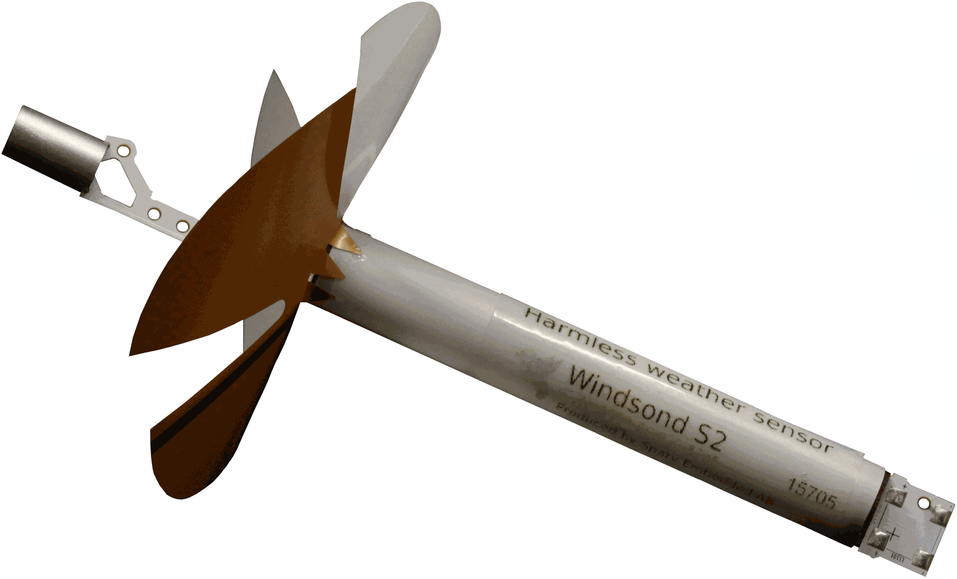
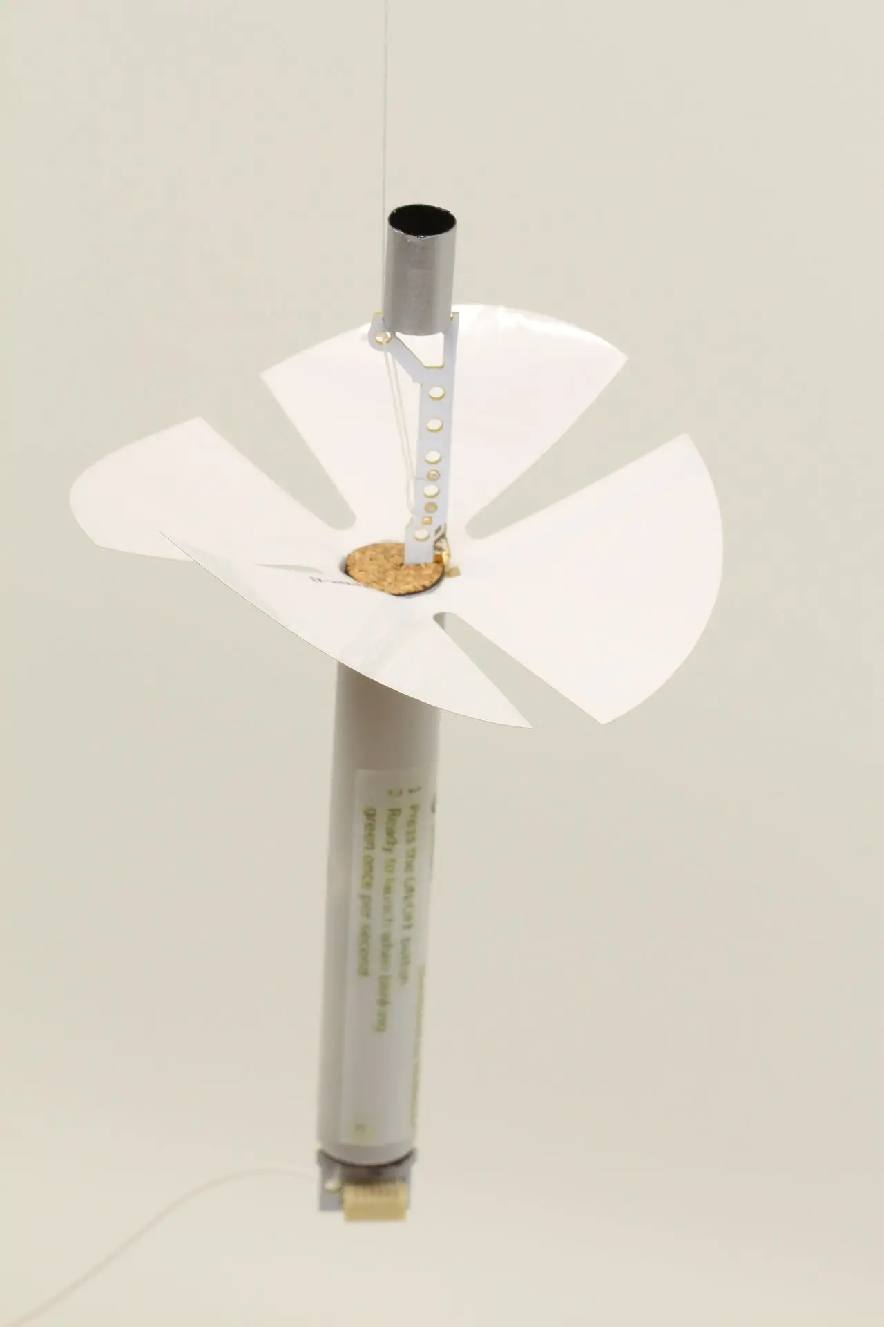
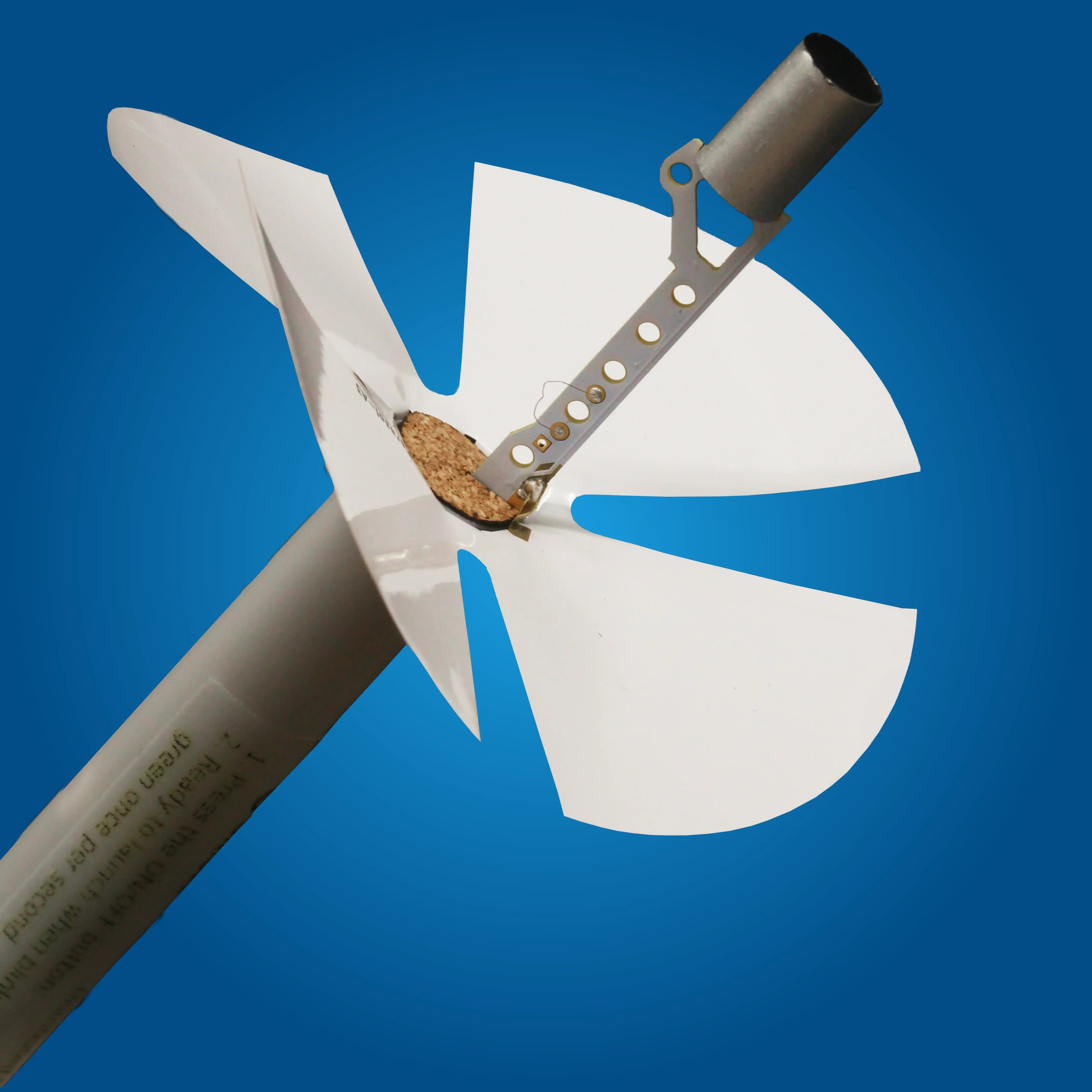
Skip to Content

Catch insights from the sky

Windsond S2

Next-gen pocket-sized radiosonde delivering real-time, WMO-grade wind, temperature, and humidity profiles with 30% less helium use and smart GPS recovery.

2

nd

Gen

WMO

Standards

Carry More Sondes, Launch Instantly, No Vehicle required

Pack Windsonds, ground station, and launch gear into a single backpack. Deploy instantly in remote or hazardous areas with no chase vehicle, no setup delay. Just grab, launch, and collect data. As simple as that.

Recover Your Sondes & Avoid Waste

Maximize Sonde Recovery. Smart built-in guide ensures precise cut-down and controlled descent for up to 90% recovery. Reuse nearly every sonde from one flight to the next, cut waste, and reduce costs.

Weather Data Whenever You Need

Don't wait for reports. Windsond S2 delivers wind, temperature and humidity readings in an instant. You always stay ahead, making decisions on the spot with complete confidence.

Windsond being deployed in the air with mountain background and a blue sky
Picture of the lightest weather sonde in the world the Windsond S2 from Sparv Embedded.

Catch insights from the sk​y

Windsond S2

Next-gen pocket-sized radiosonde delivering real-time, WMO-grade wind, temperature, and humidity profiles with 30% less helium use and smart GPS recovery

Get it now!

Carry More Radiosondes, Launch Instantly

Real-time atmospheric data collection has never been this portable. With sondes, helium, regulator, balloons, and ground station packed into one backpack, you're ready to deploy anywhere. Fast, light, and efficient

Weather Data Whenever You Need

Don't wait for reports. Windsond S2 delivers wind, temperature and humidity readings in an instant, rain or shine. You always stay ahead, making decisions on the spot with complete confidence.

Recover Your Sondes & Avoid Waste

Maximize Sonde Recovery. Smart built-in guide ensures precise cut-down and controlled descent for up to 90% recovery. You reuse (almost) all sondes flight after flight, generate less waste and save on costs.  

Windsond S2 from Sparv Embedded taken in a picture box.

Researcher holding a Windsond S2 outdoors in a park.

Woman on a mountaintop with Windsond S2 sondes for weather sampling.

Weather sonde Windsond S2 from Sparv Embedded with a blue background.

Get more information by email

Want more information about our products? Get our product guide by email directly.

Thanks for registering!

Uniquely S​mall


Complete your work by transporting more sondes

Our sondes are compact, lightweight, and optimized for rapid deployment. Weighing only a few grams, they’re easy to transport in large numbers, ensuring you're equipped for successful missions wherever you need them.
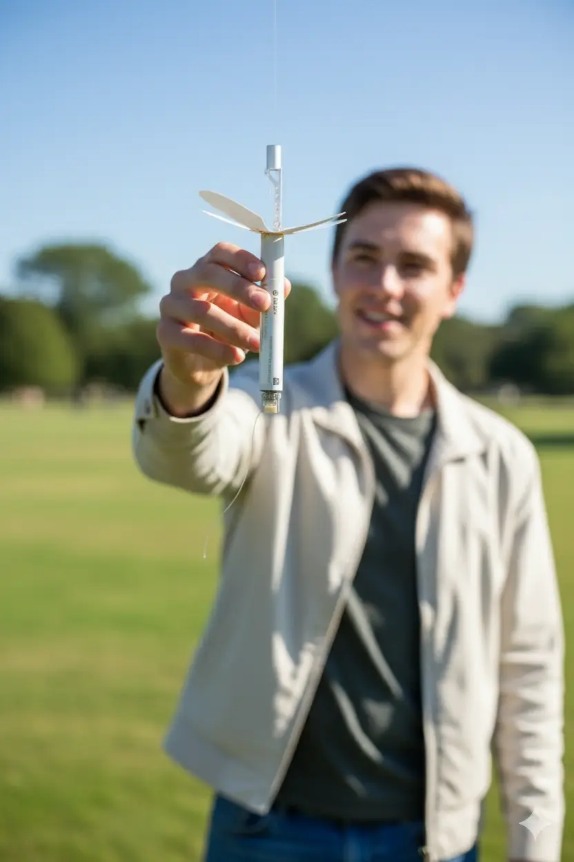
Easy to launch


Save precious time by launching in minutes

Our sondes are compact, lightweight, and designed for rapid deployment. With no bulky helium tanks required, you can launch multiple sondes from virtually any location. Setup takes just minutes, making field operations faster and more flexible. It’s a streamlined solution that saves time without compromising performance.
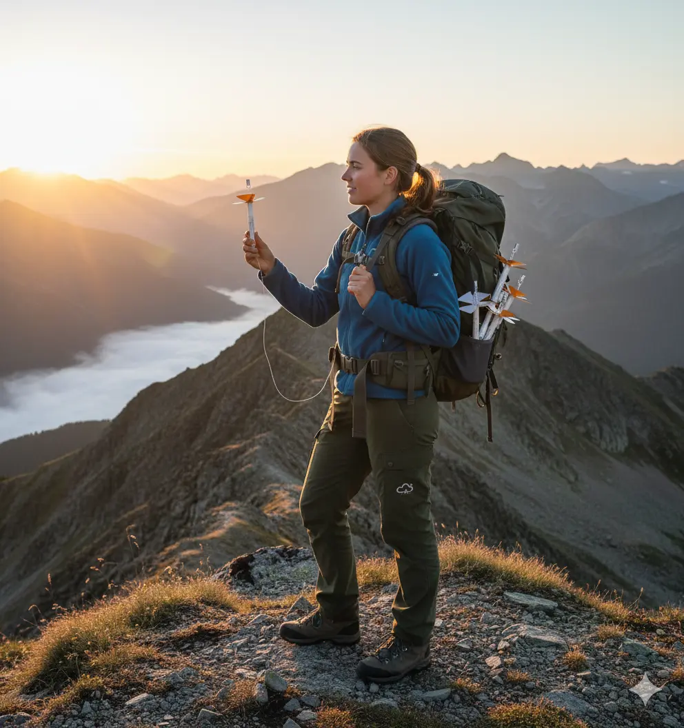
Controlled Landing


Accurate landing prediction enables easy recovery and reuse of sondes. 

Our sondes are engineered for accurate, controlled landings, saving time, equipment, and effort. With reliable prediction software and Google Earth integration, users consistently recover sondes within 10–30 meters of the forecasted spot. Recovery rates of 90% can be expected.

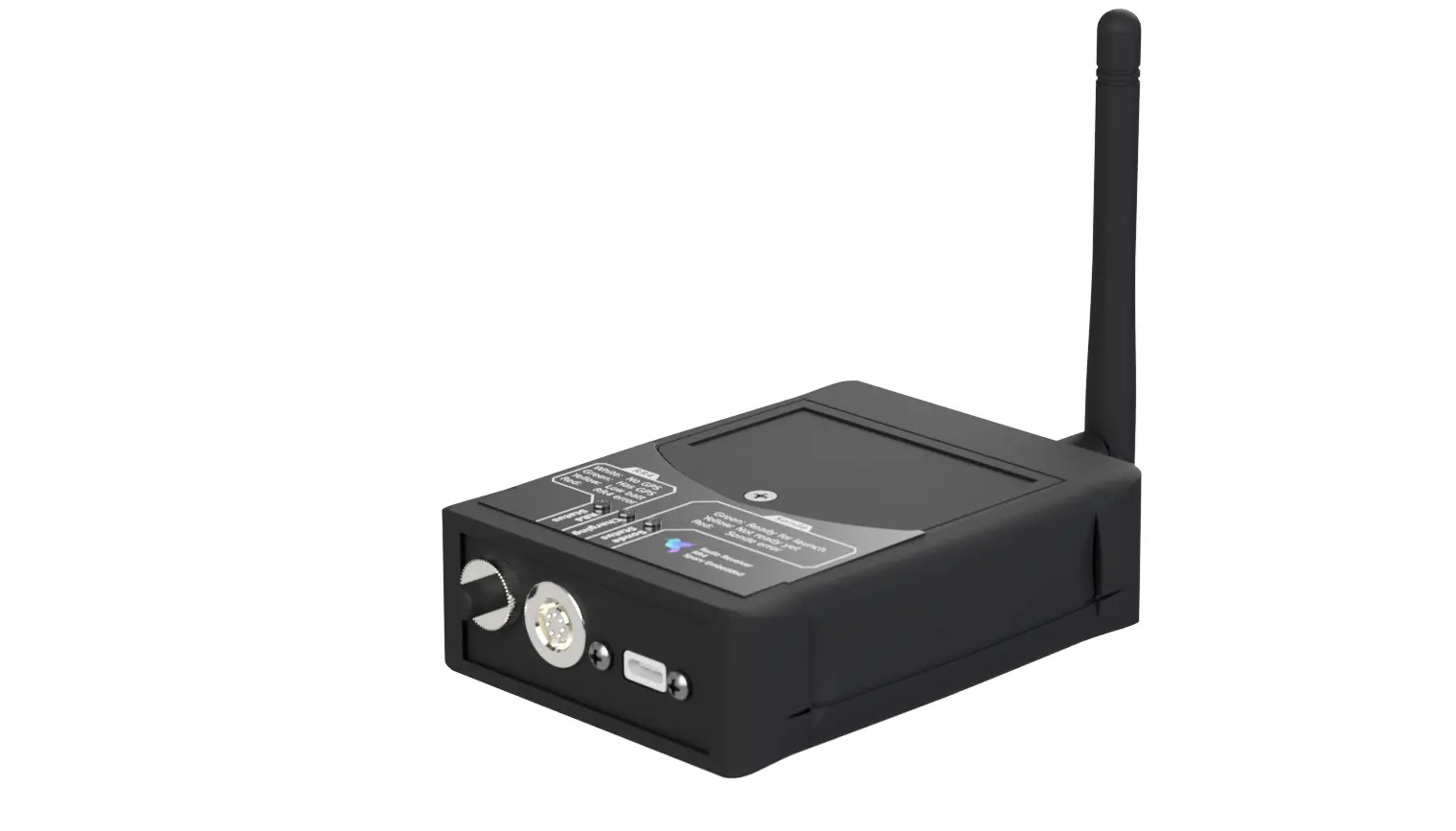
Real-time measurements


Wind, temperature and humidity profiles

Get instant information of Wind, temperature and humidity profiles through our software and instant communication tools.
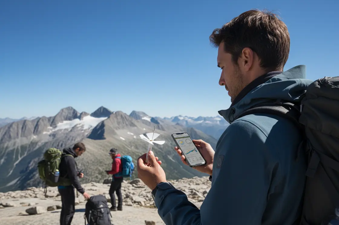
Recovery systems


 Recover up to 90% of your sondes

With a Google maps integration, you will be capable to follow the trajectory of your sondes, supervise where they land and recover them easily.

Sonde

Dive deeper into Windsond's abilties

Barometer icon indicating improved altitude accuracy up to 10 km.

Barometer to improve the altitude accuracy from the surface up to 10km

Mountain icon representing maximum altitude of 10 km above sea level.

Maximum altitude 10 km above sea level (33 thousand feet)

Water drop icon symbolizing hygrometer for humidity and dew point.

Hygrometer to measure air humidity and dew point (additional option)  

Antenna icon showing radio link with adjustable frequency and power.

Radio link with program​mable frequency and transmission power 

Wind icon representing measurement of wind direction, speed, temperature, and humidity.

Measure wind direction, wind speed, temperature and humidity

Command line icon symbolizing error-correcting code for stable radio link.

Error correcting code for robust radio link

Ground Station

Rising graph icon showing weather data in graphical and text formats

Weather conditions are reported in graphical and text formats and exported to file in “Winds” format  

Map pins icon representing support for multiple sondes and receivers

Multiple sondes and multiple receivers are supported  

Graph curve icon showing automatic averaging and interpolation of data.

Automatic averaging and interpolation of measurements

Gear icon indicating adjustable settings via graphical user interface.

Change settings with convenient graphical user interface

Globe icon showing live balloon tracking on Google Earth.

Follow the balloon live on Google Earth, right from launch to landing  

Document icon representing reloading past soundings or replaying flights.

Load earlier soundings to revisit the measurements or replay the flight

Receive data using RR4

Automatically receive Windsond data with RR4 receiver

Learn more

RR4 radio receiving signals from Windsond S2.

User-friendly Sonde Control Software​​


Bi-directional radio communication

With the sonde before, during and after soundings


Check sonde status and behavior

At a glance with the sub-system status panel


Choose sonde cut-down altitude trigger

Define the altitude at which the radiosonde should automatically detach and descend. 


Predict, visualize and control

Sonde landing location to make sonde recovery easy


Follow the balloons

Live on Google Earth or OziExplorer, right from launch to landing.


Support for 8 simultaneous sondes

customizable with Swarmsonde and/or Multisonde


Support for multiple receivers

Connect and operate several receivers simultaneously to expand coverage, improve data reliability, or enable parallel tracking.

Sonde

Dive deeper into Windsond's abilties

Barometer icon indicating improved altitude accuracy up to 10 km.

Barometer to improve the altitude accuracy from the surface up to 10km

Mountain icon representing maximum altitude of 10 km above sea level.

Maximum altitude 10 km above sea level (33 thousand feet)

Water drop icon symbolizing hygrometer for humidity and dew point.

Hygrometer to measure air humidity and dew point

Antenna icon showing radio link with adjustable frequency and power.

Radio link with programmable frequency and transmission power 

Wind icon representing measurement of wind direction, speed, temperature, and humidity.

Measure wind direction, wind speed & temperature and humidity

Command line icon symbolizing error-correcting code for stable radio link.

Error correcting code for robust radio link

Ground Station

Rising graph icon showing weather data in graphical and text formats.

Weather data in text and graphics, exportable to Winds and other formats.”  

Map pins icon representing support for multiple sondes and receivers.

Multiple sondes and multiple receivers are supported  

Graph curve icon showing automatic averaging and interpolation of data.

Automatic averaging and interpolation of measurements

Gear icon indicating adjustable settings via graphical user interface.

Change settings with convenient graphical user interface

Globe icon showing live balloon tracking on Google Earth.

Follow the balloon live on Google Earth, right from launch to landing  

Document icon representing reloading past soundings or replaying flights.

Load earlier soundings to revisit the measurements or replay the flight

RR4 receiver capturing telemetry messages from a Windsond S2

Receive data using RR4

Automatically receive Windsond data with RR4 receiver

Check the RR4​​ now

​​

User-friendly Sonde Control Software

Bi-directional radio communication

With the sonde before, during and after soundings

Check sonde status and behavior

At a glance with the sub-system status panel

Choose sonde cut-down altitude trigger

Define the altitude at which the radiosonde should automatically detach and descend. 

Predict, visualize and control

Sonde landing location to make sonde recovery easy

Follow the balloons

Live on Google Earth or OziExplorer, right from launch to landing

Supports up to 120 sondes at once 

(customizable with Swarmsonde and/or Multisonde)

Support for multiple receivers

Connect and operate several receivers simultaneously to expand coverage, improve data reliability, or enable parallel tracking.

Customization

Customization for special software development needs available by the Sparv Embedded team

Windsond Desktop software showing graphs data.
Windsond Desktop showing Windsond S2 measurement graphs
Windsond Desktop showing Windsond S2 measurement graphs.


Release of Windsond

By Firefighters


Release of two Windsond S1 by firefighters

During wildfired spread in Catalonia, Spain


Windsond S2


Windsond S2

Numbers don't lie

Take a look at those numbers, they might be more useful than long speeches.

10000

Windsond S1 units sold

13 

years of activity

30+ 
countries we have sold to

Numbers don't lie

Take a look at those numbers, they might be more useful than long speeches.

30+

Countries we've sold to

10 000+

Windsond S1 units sold

13years

of activity

Let them tell you their story...

About the Windsond S2 and Sparv's products in general

John Horel, Professor, Department of Atmospheric Sciences, University of Utah

"For us, the main advantages of using Windsond S2 are: 

  1. Cost effectiveness, portability, and ease of use for educational applications
  2. For research, as we are interested in boundary layer flows, it is highly cost effective to be able to cut down sondes and reuse. 
  3. Less helium required (affects cost and also reduces impact of using a nonrenewable resource)
  4. Very easy to use receiver/software and sondes
  5. Real-time displays during flight, use of google earth
  6. Public outreach events by flying as a "tethered balloon" (using a fishing rod)"

Let them tell you their story...

About the Windsond S2 and Sparv's products in general

John HorelProfessor, Department of Atmospheric Sciences, University of Utah

“For us, the main advantages of using Windsond S2 are: 

  1. Cost effectiveness, portability, and ease of use for educational applications
  2. For research, as we are interested in boundary layer flows, it is highly cost effective to be able to cut down sondes and reuse. 
  3. Less helium required (affects cost and also reduces impact of using a nonrenewable resource)
  4. Very easy to use receiver/software and sondes
  5. Real-time displays during flight, use of google earth
  6. Public outreach events by flying as a "tethered balloon" (using a fishing rod)"

Sus​tainable by design  

At Sparv, we design reusable products that are 100% free of heavy metals, protecting ecosystems and preventing long-term environmental harm. We hire and invest in local talent to strengthen communities, and we rigorously meet, and often exceed, all environmental regulations.

Sus​tainable by design 

At Sparv, we design reusable products that are 100% free of heavy metals, protecting ecosystems and preventing long-term environmental harm. We hire and invest in local talent to strengthen communities, and we rigorously meet, and often exceed, all environmental regulations.
Frequently Asked Question section for the Windsond product from Sparv Embedded.

FAQ - Windsond

Do you have more question about Windsond? Here is our FAQ where you will be able to find complementary information.

To the Windsond FAQ

Technical capabilities

Size

Length 145 mm (excluding antenna), Diameter 12 mm (excluding parasol)

Weight

9 grams

Power

Internal rechargeable Lithium battery

Tether Line

5 m, included on spool  

Packing

Two sondes pack into a plastic tube 200 mm long, 32mm diameter

Max altitude

10 000 m MSL

Sounding time (to 10 km)

At 3 m/s ascent speed: 56 minutes, At 5 m/s ascent speed: 34 minutes

Battery Life

3,5 h at 25°C

Radio Range

100 km line-of-sight

Sondes per frequency

3 (can be changed up to 120)

Fall Speed

Radiosonde: 8 m/s at sea level, Dropsonde: 4 m/s at sea level (fall speed can be customized)

Temperature

1 Hz

Humidity

1 Hz

Pressure

1/3 Hz, interpolated to 1 Hz

Winds

1 Hz

Position

1/3 Hz

Light level

When the light level changes

Battery voltage

When the voltage changes

Resolution

1 m

Uncertainty, in flight

13 m, assuming an accurate ground elevation figure

Uncertainty of GNSS-based altitude at ground level

6 m

Range

Wind speed: 0 - 150 m/s ; Wind direction: 0 - 360°, true or magnetic

Resolution

Wind speed: 0.1 m/s; Wind direction: 0.1°

Uncertainty

Wind speed: 0.5°C with solar radiation correction; Wind direction: 5%RH for temperatures above -20°C

Measurement range

Temperature: -55°C / +60°C; Humidity: 0 / 100%RH

Resolution

Temperature: 0.01°C; Humidity: 0.05 %RH

Uncertainty

Temperature: 0.5°C with solar radiation correction; Humidity: 5%RH for temperatures above -20°C

Response Time (T63%)

Wind speed: 6 sec; Wind direction: < 8 sec at 25°C. Higher at low temperatures.

Measurement range

Temperature: -30°C / +50°C; Humidity: 0 / 100%RH

Resolution

Temperature: 0.01°C (capable of 0.002°C); Humidity: 0.01 %RH

Uncertainty

Temperature: TBD (target 0.1°C); Humidity: TBD (target 3 %RH)

Response Time (T63%)

Wind speed: 0.32 sec; Wind direction: 0.5 sec at 25°C

Frequency range

400 - 406 MHz or 433 - 436 MHz (programmable)

Range

Over 100 km with standard antenna and free line-of-sight

Power

Programmable up to 13 dBm (standard option P13). Programmable up to 20 dBm (option P20)

Bandwidth

125 kHz

Simultaneous soundings

Configurable 1-126 sondes (the default setting is 3)

Modulation

LoRa modulation with configurable parameters

Regulations

License-free ISM band operation in EU (option P13). Complies with ETSI EN 302 054.

A latex balloon is included. Up to 5000 m AGL, we recommend the 9 gram balloon (option B9). For 5000-10000 m AGL, we recommend the 20 gram balloon (option B20).

Port: 6-pin "SSP" port

Purpose: Configuration, log readout, firmware upgrade, external sensors. External power and battery charging.

Port: Internal I2C port

Purpose: Addons such as accelerometer.

Port: Internal mezzanine connector

Purpose: H4 sensors and other addons using UART, I2C, SPI and/or GPIO

“Windsond Desktop”. Requirements: A 64-bit operating system and a x86-64 based CPU. Windsond 10 or later. 1 GB free RAM. 120 MB free storage space. Linux support on request.

Onboard logging

Reusable: Cut-down, speaker, bright LED, rechargeable battery

Fast-response temperature and humidity sensor

Accelerometer, gyro and compass

External sensors

FAQ - Windsond

Do you have more question about Windsond? Here is our FAQ where you will be able to find complementary information.

To the Windsond FAQ

Technical capabilities

Temperature

-45 °C ~ +45 °C

Max altitude

8000 meter above ground level

9000 meter above sea level

Weight (excluding balloon)

Configuration below 5000 m: 12 gram

Configuration above 5000 m: 13 gram

Suggested helium consumption at 1.5 m/s rise rate

Configuration below 5000 m: 30 liters

Configuration above 5000 m: 60 liters

Simultaneous soundings per receiver

8 (Standard Sondes). Ask if you need > 8

simultaneous soundings per receiver

Type

Bidirectional UHF radio

Modulation

GFSK

Frequency​

Configurable 400 ~ 480 MHz

Power​

Configurable, max 100 mW  

Range, with unobstructed view

Omni-directional receiver antenna: >15 km 

Directional receiver antenna: >60 km

Measurement frequency

1Hz

Ground station antenna connector type

SMA

Feature - Range - Resolution - Accuracy - Unit

Air Pressure - 300/1100 - 0.02 - 1.0 - hPa

Wind Speed - 0/150 - 0.1 - ca 5% - m/s

Wind Direction - 0/360 - 0.1 - Depends on GPS condition - degrees 

Did you own an older model?

If you were a Windsond S1 customer, you can find all the information about Windsond S1.

To the Windsond S1 page

Dual/Multiple Balloons Launching

Want to throw two balloons at once ? Look how you can do here.   

More Details

Request a quote

You can buy the product directly here, but if you would like a quote before, do not hesitate to contact us!