Our first radiosonde
Windsond S1
Windsond is the first weather balloon system thta Sparv made for an immediate view of local conditions.
While the model is not produced anymore, you can find all the information on this page.
Our first radiosonde
Windsond S1
Windsond is the first weather balloon system thta Sparv made for an immediate view of local conditions.
While the model is not produced anymore, you can find all the information on this page.
Extremely compact design
Uniquely small size for easy transport and deployment, enabling lightweight canisters and lower logistics overhead
Helium-efficient and reusable
Saves precious helium and reduces canister size; sondes are recoverable and reusable for best economy
Real-time atmospheric profiling
Live wind, temperature, and humidity profiles with user‑friendly ground‑station software and reliable recovery (even days later)
Predictable recovery and control
Tools to predict and control landing location, simplifying retrieval and outreach deployments
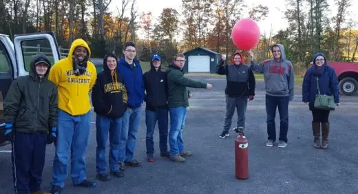
More than 10 000+ units sold
More than
10 000+
units sold
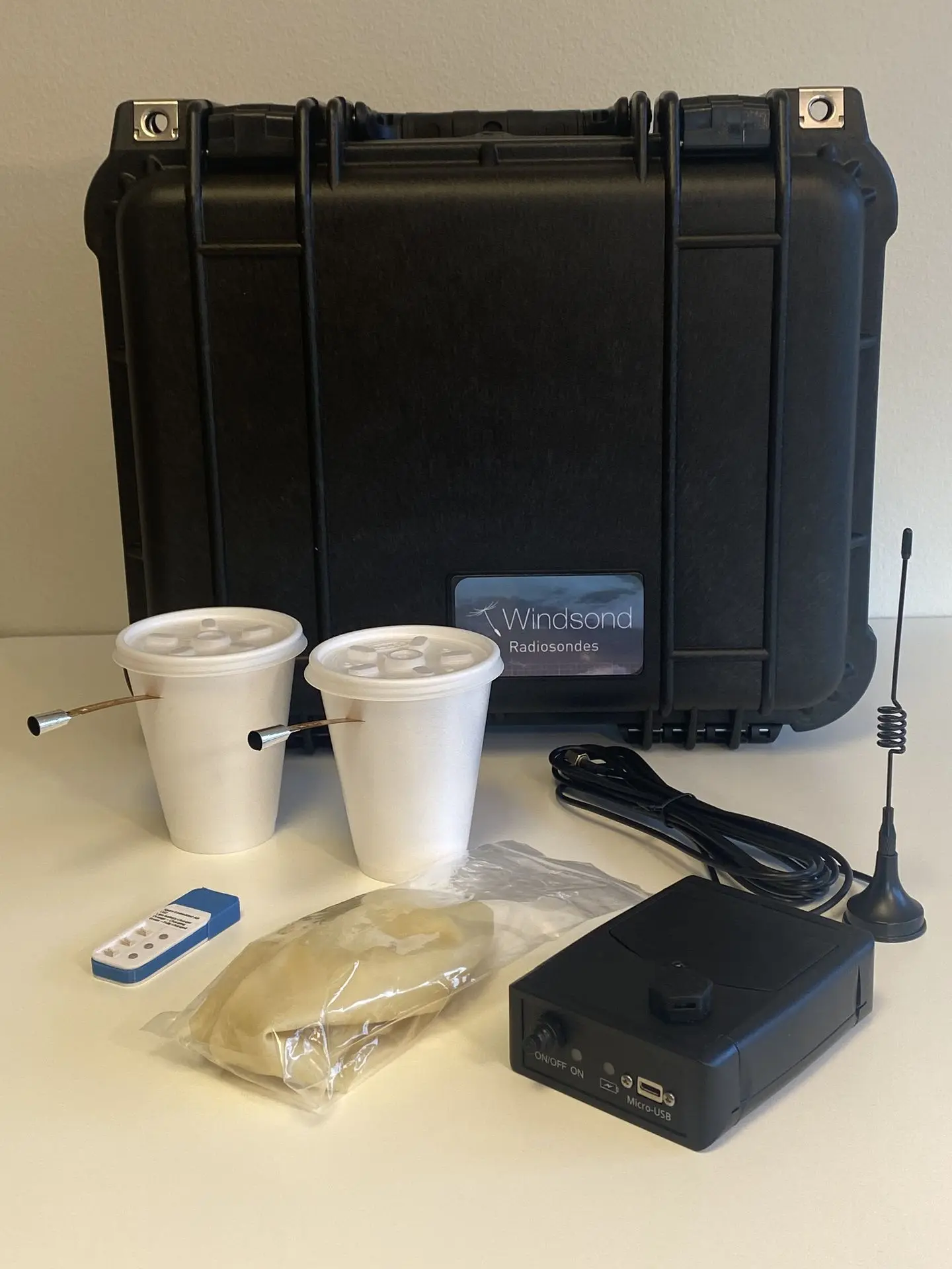
Hardware
Sonde
- Measure wind direction, wind speed and temperature
- Hygrometer to measure air humidity and dew point (additional option)
- Barometer to improve the altitude accuracy from 100m to 7m
- Simple sonde activation by a switch. Sounds indicate when the sond is ready for launch.
- Reusable sondes as an option with added cut-down wires and smart tracking features.
- Sonde cut-down altitude (reusable sondes) configurable by user, also during flight
- Maximum altitude 8-9 km meter above sea level (26-30 thousand feet)
- Radio link with programmable frequency and transmission power.
- Specially developed error correcting code for more robust radio link.
- No heavy metal content for small environmental impact.
Ground Station
- Review weather conditions even as the balloon ascends
- Weather conditions are reported in graphical and text formats and exported to file in “Winds” format
- Automatic averaging and interpolation of measurements
- Follow the balloon live on Google Earth, right from launch to landing
- Multiple sonds and multiple receivers are supported
- Change settings with convenient graphical user interface
- Keep another sond in the car to compare the positions of the balloon and the car
- Load earlier soundings to revisit the measurements or replay the flight
Software
Sonde Control
- Bi-directional radio communication with the sonde before, during and after soundings
- Check sonde status at a glance with the sub-system status panel

- Check sonde status and behaviour
- Choose sonde cut-down altitude trigger
- Predict, visualize and control sonde landing location to make sonde recovery easy
- Follow the balloon live on Google Earth or OziExplorer, right from launch to landing
- Support for 8 simultaneous sondes (customizable with Swarmsonde and/or Multisonde)
- Support for multiple receivers
Customization
Sparv Embedded looks forward to serving your specific needs with custom software development.
Sonde reuse
“Recovery rates of 90% can be expected”
The Windsond radiosondes are designed for reuse. While the small size makes for minimal environmental impact if not recovered and the sondes are affordable even as is, the easy and dependable recovery can make the price of each sounding marginal.
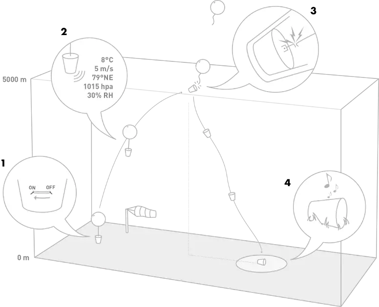
Operation sequence:
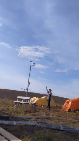
- Turn on the sonde by sliding the switch. Wait for the sonde to acquire a GPS fix. Release the sonde.
- The sonde measures and transmits data to the ground
- At the set peak altitude, the sonde detaches from the balloon tether line. The sonde starts to fall.
- When the sonde has landed, it will blink and beep to be easier to find.
Three factors helps the recovery:
Pick a convenient landing site
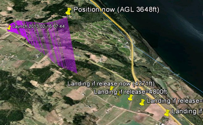
Specially developed algorithms lets the user choose landing site with about 50m accuracy. The sonde has the capability to do a controlled cut-down from the balloon based on altitude or at direct trigger from the ground station, transmitted via radio. A map shows predicted landing locations depending on the altitude where the sonde should let go from the balloon to fall back to earth. These locations form a line throughout the landscape where a landing is possible given the current wind conditions. The user can change the peak altitude at any time to make the sonde land in an easily accessible location.
Get landing coordinates
The ground station updates the predicted landing location as the sonde falls, even if radio contact is lost. The final location is known with about 10 meters of uncertainty. The upcoming Android ground station shows the way to the sonde on a map and as a compass arrow.
Sonde beeps and blinks
The operator makes way to the landing site, where the sonde restores radio contact and starts to blink and beep. Even if landing in snow or rough terrain, finding the sonde is easy.
The power-save mode makes the sonde lay dormant for days before activated by the proximity of the ground station.
This short clip shows how easy the sonde is to spot even in fresh snow.
" We took radiosondes from Windsond with us on a recent overseas field trip and we were absolutely delighted with them. They were incredibly simple to use, very easy to deploy and supported by ground station software that did exactly what it was meant to. The staff were brilliant and turned around a last minute request from us in the days leading up to our deployment. Both the company and the hardware are thoroughly recommended. Many thanks to all at Windsond."
"Our Windsond operations have been a successful endeavor. Our use has been twofold: education in elementary and middle schools, and boundary layer research. We used the Windsond system as a complement to a research aircraft. The aircraft could get soundings down to 1000 ft (ca 300m), and we would launch a sonde to that height directly underneath to instantaneously complete the profile. We have used the reusable radiosondes S1H2-R. We have done about twelve launches total, with four of them reused, and have not yet lost or damaged a single one! The sondes work very well. In terms of performance, they seem to do exactly as advertised. I have found that the antenna has better reception when attached to a large sheet of metal (car roof). We have trained about ten students to use the system, and involved nearly fifty others in hands-on operation; this amounts to about half of our department. The software is easy to use and the landing prediction has thus far performed as well as possible."
"I was using the Windsond sounding system for my field campaign in northern Canada this summer. I was very happy with the system. I really liked the software, easy to use and to understand. My objective was to find the boundary layer height, the software allowed me to detect it by looking at the potential temperature profile that is generated. I was also impressed by the accuracy of the landing prediction and by the google earth extension, I found most of my sounds in a range of 10 to 30 meters around the landing prediction spot and by bringing the RR2 with me, it was easy to spot them."
“I have been using the Windsond system in pretty harsh conditions in Puerto Rico. I have to say that it is has been responding efficiently. I particularly like the ease of use. It merely takes us 2-3 minutes to set up and launch. The other system we had in the past would take 15-20 minutes. We have used the single-use radiosondes S1H3-S. I also really like the software, the standard graphs displayed are very effective; I think plenty of thought has gone in to it. My undergraduate research assistants are learning quite a bit. On almost all the times, the sondes reached a maximum height of 10 000m. We are in the tropics. Except ones when it was caught in a thunderstorm.”
“I have launched several Windsonds and the system is fantastic. Data is high quality, accurate, and valuable. Several of the Windsonds I’ve launched have exceeded expectations and data was collected to 35,000 feet (about 10,600m). I’ve received data from 30-40 miles away. I love Windsond, I’m glad it exists and I hope its around forever!”
“I’ve done a couple of soundings now, and so far I’m very happy with the system! The mobility is a real plus – with no need to carry a big helium canister, we can launch a series of sondes anywhere. And the software is very easy to use and sensible output formats. We use Windsond” to let students explore the structure of the boundary layer, and learn by interpreting what they find. Without Windsond, basic atmospheric phenomena (lapse-rates, inversions) are just theory subjects. Nothing makes students (or their teachers) more interested in a subject than discovering that the real world differs from the text-book!"
Articles
Several researchers have been using Windsond, here is a non exhaustive list of articles in which Windsond is used for scientific purpose:
- Markowski, P.M.; Richardson, Y.P.; Richardson, S.J.; Peterson, A., Aboveground thermodynamic observations in convective storms from balloon borne probes acting as pseudo-lagrangian drifters., Bull. Am. Meteorol. Soc.2018, 99, 711–724.
- Bessardon, G.E.Q.; Fosu-Amankwah, K.; Petersson, A.; Brooks, B.J., Evaluation of Windsond S1H2 Performance in Kumasi during the 2016 DACCIWA Field Campaign., Atmos. Meas. Tech. 2019, 12, 1311–1324.
- White, L.D.; Lu, D., Multi-Scale Transects of Three North American Drylines., Atmosphere 2020, 11, 854.
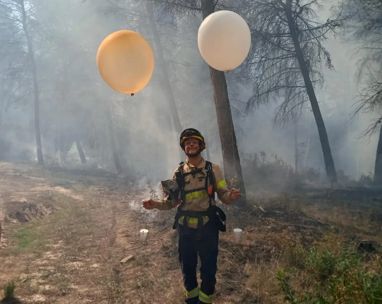
- Castellnou, M.; Bachfischer, M.; Miralles, M.; Ruiz, B.; Stoof, C.R.; Vila-Guerau de Arellano, J., Pyroconvection Classification Based on Atmospheric Vertical Profiling Correlation With Extreme Fire Spread Observations, JGR Atmospheres. 2022, Volume127, Issue22
- C. Lyn Comer, Braedon Stouffer, David J. Stensrud, Yunji Zhang, Matthew R. Kumjian, An Automated Approach to Estimating Convective Boundary Layer Depth from Dual-Polarization WSR-88D Radar Observations, Journal of Atmospheric and Oceanic Technology, 41(8), 767-780. https://doi.org/10.1175/JTECH-D-23-0166.1
- Soderholm, J. S., M. R. Kumjian, J. P. Brook, A. Peterson, A. Protat, J. Brimelow, S. Trömel, and M. Kunz,, 2025: Measuring Hail-like Trajectories and Growth with the Hailsonde., Bull. Amer. Meteor. Soc., 106, E2128–E2142, https://doi.org/10.1175/BAMS-D-24-0021.1.
- Crosman, E., A. M. Ward, S. W. Bieda, T. T. Lindley, M. Gittinger, S. Pal, and H. Vepuri,, 2023: Engaging Undergraduate Students in Collaborative Field Research with the U.S. National Weather Service: The SCORCHER Study., Bull. Amer. Meteor. Soc., 104, E652–E659, https://doi.org/10.1175/BAMS-D-22-0113.1.
- Fischer, J., Groenemeijer, P., Holzer, A., Feldmann, M., Schröer, K., Battaglioli, F., Schielicke, L., Púčik, T., Antonescu, B., Gatzen, C., and TIM Partners:, Invited perspectives: Thunderstorm intensification from mountains to plains, Nat. Hazards Earth Syst. Sci., 25, 2629–2656, https://doi.org/10.5194/nhess-25-2629-2025, 2025.
Media
David Templeton, Pittsburgh Post-Gazette. Nov 24, 2017, “Stupidly simple” way to use party balloons to study tornadoes., Download as PDF
Matthew Cappucci, The Washington Post. July 25, 2019, This team of scientists launches weather balloons into violent storms. What they learn could improve tornado forecasts., Link
Stephanie Kossman, Brookhaven National Laboratory Newsroom, July 19, 2022, Mapping Urban Heat From the Ground Up, Link
Video: Pyroconvection Classification Based on Atmospheric Vertical Profiling, January 27, 2023